Scientific Econometric Analysis of Cultural Heritage Digitization in the Past Five Years: Based on CiteSpace, VOSviewer, and SciMAT
Abstract
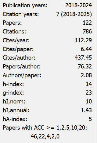
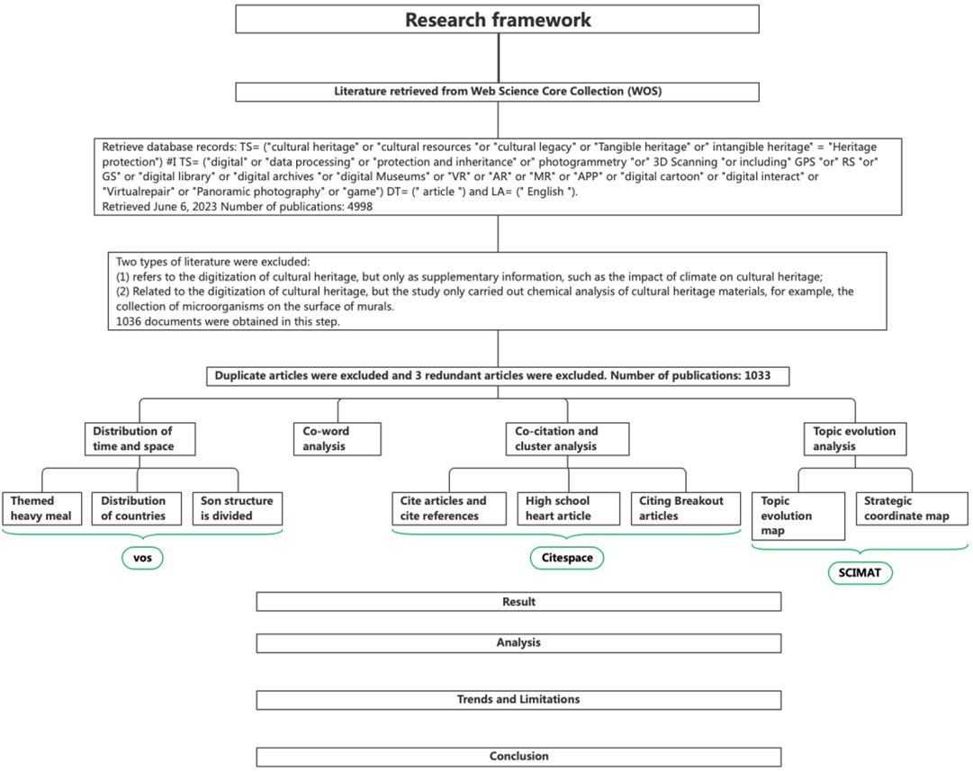
This article aims to systematically review and analyze the research laws, key technological elements, and cutting-edge development trends in the field of digitalization of cultural heritage, laying a theoretical foundation for future research plans and providing reference for promoting further development in this field. Using bibliometrics and CiteSpace, VOSviewer, and SciMAT software based on the Web of Science database, a qualitative and quantitative analysis was conducted on the digital literature knowledge graph of cultural heritage from 2020 to 2024. The results obtained econometric maps from macro to micro perspectives, combined with background information, current trends, and knowledge structure analysis of spatiotemporal, co word, clustering, theme evolution, and other charts, exploring the evolution of this field from various angles. The digitization of cultural heritage has gradually developed from the initial stage to a new stage of global cooperation and policy application. The characteristic of this transitional process is that the research focus gradually shifts from the attention to culture itself to the application of technological means, and ultimately expands to the display and dissemination of cultural heritage. This article also summarizes several development trends in this field, including integration, proceduralization, technologicalization, standardization, intelligence, etc., while also exploring the current limiting factors.
References
[2] Susemihl, G. (2023). Ideas, concepts and uses of heritage. In Claiming back their heritage: Indigenous empowerment and community development through world heritage (pp. 25–88). Springer Nature Switzerland. https://doi.org/10.1007/978-3-031-40063-6_2
[3] Croce, V. (2023). Digital heritage classification via machine learning and H-BIM. Nexus Network Journal, 25(Suppl 1), 415–421. https://doi.org/10.1007/s00004-023-00732-7
[4] Croce, V. (2023). Digital heritage classification via machine learning and H-BIM. Nexus Network Journal, 25(Suppl 1), 415–421. https://doi.org/10.1007/s00004-023-00732-7
[5] O’Neill, B., & Stapleton, L. (2022). Digital cultural heritage standards: From silo to semantic web. AI & Society, 37(3), 891–903. https://doi.org/10.1007/s00146-021-01310-4
[6] Dore, C., & Murphy, M. (2012). Integration of Historic Building Information Modeling (HBIM) and 3D GIS for recording and managing cultural heritage sites. ISPRS Annals of the Photogrammetry, Remote Sensing and Spatial Information Sciences, I-2, 57–64. https://doi.org/10.5194/isprsannals-I-2-57-2012
[7] Pepe, M., Costantino, D., Alfio, V. S., et al. (2021). Scan to BIM for the digital management and representation in 3D GIS environment of cultural heritage site. Journal of Cultural Heritage, 50, 115–125. https://doi.org/10.1016/j.culher.2021.05.006
[8] López, F. J., Lerones, P. M., Llamas, J., Gómez-García-Bermejo, J., & Zalama, E. (2018). A review of heritage building information modeling (H-BIM). Multimodal Technologies and Interaction, 2(2), Article 21. https://doi.org/10.3390/mti2020021
[9] Fregonese, L., Giovanola, C., Lingua, A., et al. (2017). 4D reconstruction and visualization of cultural heritage: Analyzing our legacy through time. International Archives of the Photogrammetry, Remote Sensing and Spatial Information Sciences, XLII-2/W3, 609–616. https://doi.org/10.5194/isprs-archives-XLII-2-W3-609-2017
[10] López, F. J., Lerones, P. M., Llamas, J., et al. (2018). A review of heritage building information modeling (H-BIM). Multimodal Technologies and Interaction, 2(2), Article 21. https://doi.org/10.3390/mti2020021
[11] Jo, Y. H., & Hong, S. (2019). 3D digital documentation of cultural heritage using terrestrial laser scanning and UAV photogrammetry. ISPRS International Journal of Geo-Information, 8(2), Article 53. https://doi.org/10.3390/ijgi8020053
[12] Dore, C., & Murphy, M. (2020). HBIM modelling: From surface meshes to knowledge representation. ISPRS International Journal of Geo-Information, 8(3), Article 301. https://doi.org/10.3390/ijgi8030301
[13] Bekele, M. K., Pierdicca, R., Frontoni, E., et al. (2018). A survey of augmented, virtual, and mixed reality for cultural heritage. Journal on Computing and Cultural Heritage, 11(2), Article 7. https://doi.org/10.1145/3161602
[14] Remondino, F., & Campana, S. (2017). Recent trends in cultural heritage 3D survey: The photogrammetric computer vision approach. Journal of Cultural Heritage, 26, 176–184. https://doi.org/10.1016/j.culher.2017.02.006
[15] Remondino, F., & Campana, S. (2017). Recent trends in cultural heritage 3D survey: The photogrammetric computer vision approach. Journal of Cultural Heritage, 26, 176–184. https://doi.org/10.1016/j.culher.2017.02.006
[16] Jaud, M., Passot, S., Le Bivic, R., et al. (2019). Accuracy of unmanned aerial vehicle (UAV) and SfM photogrammetry survey as a function of the number and location of ground control points used. Remote Sensing, 11(6), Article 685. https://doi.org/10.3390/rs11060685
[17] Champion, E., & Bekele, M. K. (2019). A comparison of immersive realities and interaction methods: Cultural learning in virtual heritage. Frontiers in Robotics and AI, 6, Article 91. https://doi.org/10.3389/frobt.2019.00091
[18] Bozzelli, G., Raia, A., Ricciardi, S., De Nino, M., Barile, N., Perrella, M., Tramontano, M., Pagano, A., & Palombini, A. (2019). An integrated VR/AR framework for user-centric interactive experience of cultural heritage: The ArkaeVision project. Digital Applications in Archaeology and Cultural Heritage, 15, Article e00124. https://doi.org/10.1016/j.daach.2019.e00124
[19] Jones, A., Smith, B., Wilson, P., et al. (2021). An application of integrated 3D technologies for reproducing cultural heritage. ISPRS International Journal of Geo-Information, 10(5), Article 263. https://doi.org/10.3390/ijgi10050263
[20] Li, J., Pan, J., Dou, Q., Fu, F., & Shi, Y. (2024). Digital footprint as a public participatory tool: Identifying and assessing industrial heritage landscape through user-generated content on social media. Landscape and Urban Planning, 250, Article 105124. https://doi.org/10.1016/j.landurbplan.2024.105124
[21] Boboc, R. G., Băutu, E., Gîrbacia, F., et al. (2022). Augmented reality in cultural heritage: An overview of the last decade of applications. Applied Sciences, 12(19), Article 9859. https://doi.org/10.3390/app12199859
[22] Liang, H., Li, W., Lai, S., Zhu, L., Jiang, W., & Zhang, Q. (2018). The integration of terrestrial laser scanning and terrestrial and unmanned aerial vehicle digital photogrammetry for the documentation of Chinese classical gardens – A case study of Huanxiu Shanzhuang, Suzhou, China. Journal of Cultural Heritage, 33, 222–230. https://doi.org/10.1016/j.culher.2018.02.015
[23] Jouan, P., & Hallot, P. (2020). Digital twin: Research framework to support preventive conservation policies. ISPRS International Journal of Geo-Information, 9(4), Article 228. https://doi.org/10.3390/ijgi9040228
[24] Marra, A., Gerbino, S., Greco, A., et al. (2021). Combining integrated informative system and historical digital twin for maintenance and preservation of artistic assets. Sensors, 21(17), Article 5956. https://doi.org/10.3390/s21175956
[25] Alshawabkeh, Y., El-Khalili, M., Almasri, E., Bala’awi, F., & Al-Massarweh, A. (2020). Heritage documentation using laser scanner and photogrammetry. The case study of Qasr Al-Abidit, Jordan. Digital Applications in Archaeology and Cultural Heritage, 16, Article e00133. https://doi.org/10.1016/j.daach.2020.e00133
[26] Liang, H., Li, W., Lai, S., et al. (2018). The integration of terrestrial laser scanning and terrestrial and unmanned aerial vehicle digital photogrammetry for the documentation of Chinese classical gardens – A case study of Huanxiu Shanzhuang, Suzhou, China. Journal of Cultural Heritage, 33, 222–230. https://doi.org/10.1016/j.culher.2018.02.015
[27] Grilli, E., & Remondino, F. (2019). Classification of 3D digital heritage. Remote Sensing, 11(7), Article 847. https://doi.org/10.3390/rs11070847
[28] López, F. J., Lerones, P. M., Llamas, J., et al. (2018). A review of heritage building information modeling (H-BIM). Multimodal Technologies and Interaction, 2(2), Article 21. https://doi.org/10.3390/mti2020021
[29] Pepe, M., Costantino, D., & Restuccia Garofalo, A. (2020). An efficient pipeline to obtain 3D model for HBIM and structural analysis purposes from 3D point clouds. Applied Sciences, 10(4), Article 1235. https://doi.org/10.3390/app10041235
[30] Jo, Y. H., & Hong, S. (2019). Three-dimensional digital documentation of cultural heritage site based on the convergence of terrestrial laser scanning and unmanned aerial vehicle photogrammetry. ISPRS International Journal of Geo-Information, 8(2), Article 53. https://doi.org/10.3390/ijgi8020053
[31] Dai, A., Qi, C. R., & Nießner, M. (2017). Shape completion using 3D-encoder-predictor CNNs and shape synthesis. In 2017 IEEE Conference on Computer Vision and Pattern Recognition (CVPR) (pp. 6545–6554). IEEE. https://doi.org/10.1109/CVPR.2017.692
[32] Aicardi, I., Chiabrando, F., Lingua, A. M., & Noardo, F. (2018). Recent trends in cultural heritage 3D survey: The photogrammetric computer vision approach. Journal of Cultural Heritage, 32, 257–266. https://doi.org/10.1016/j.culher.2017.11.006
[33] Yang, X., Grussenmeyer, P., Koehl, M., Macher, H., Murtiyoso, A., & Landes, T. (2020). Review of built heritage modelling: Integration of HBIM and other information techniques. Journal of Cultural Heritage, 46, 350–360. https://doi.org/10.1016/j.culher.2020.05.008

This work is licensed under a Creative Commons Attribution 4.0 International License.
Copyright for this article is retained by the author(s), with first publication rights granted to the journal.
This is an open-access article distributed under the terms and conditions of the Creative Commons Attribution license (http://creativecommons.org/licenses/by/4.0/).