Soil Erosion in Important Agricultural Areas of Haidong City, Qinghai Province, China
Abstract
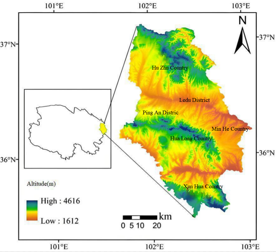
Haidong City is located in the eastern region of the Tibetan Plateau and the upper reaches of the Yellow River, which is an important agricultural area in Qinghai Province. Surface soil erosion in this area not only reduces soil quality, but also leads to the pollution of the Yellow River water and the increase of sand transport.The soil erosion status of Haidong City in 2022 was assessed using the modified soil loss equation (RUSLE model), combined with landsat8 OLI imagery, DEM, rainfall and land use data, and RS and GIS techniques. The results show that soil erosion in Haidong City is dominated by slight and mild erosion, with an area of 7,835 km2 and 2,735 km2 respectively.Among the districts (counties), Ledu District and Mutual aid County have the largest area of strong erosion, with an area of 633 km2 and 144 km2 respectively; Ping'an District and Minhe County have a smaller area of strong erosion, with an area of 11 km2 and 30 km2 respectively.Between the different land-use types. grassland erosion area was the largest, with an area of 7449km2, accounting for 59.83%. The results of the above study can provide a scientific basis for soil degradation management in the region to meet the challenges of fragile ecological environment and increasing land use.
References
Jia, W., Gao, X., & Gu, X. (2020). Analysis on environmental carrying capacity of land resources in Huangshui Basin. The Administration and Technique of Environmental Monitoring, 32(6), 13–17.
Jiang, G., Kang, J., Cao, G., et al. (2022). Study on soil erosion of Lancang River Basin in Qinghai based on RUSLE model. Plateau Science Research, 6(4), 1–13.
Liu, B. Y., Nearing, M. A., & Risse, L. M. (1994). Slope gradient effects on soil loss for steep slopes. Transactions of the ASAE, 37(6), 1835–1840. https://doi.org/10.13031/2013.28273
Liu, B., Zhang, B., Liao, J., et al. (2022). Ecological status evaluation of ecological function area of water and soil conservation based on RS and GIS. The Administration and Technique of Environmental Monitoring, 34(3), 35–39.
Liu, F., Qu, W., & You, X., et al. (2019). Calculation of slope factor taking into consideration forest-grass cover. Surveying and Mapping, 42(1), 42–46.
Ma, J. (2023). The response of ecosystem services to changing landscape patterns on the Qinghai-Tibet Plateau: A case study from eastern Qinghai [Doctoral dissertation, Chang’an University].
Ma, Y., He, H., & Zhao, H. (2023). Spatiotemporal change of soil erosion in Gannan Tibetan Autonomous Prefecture based on GIS and RUSLE. Research of Soil and Water Conservation, 30(3), 37–46.
Song, Q., Gao, X., Gu, X., et al. (2024). Estimation of soil organic carbon content in farmland based on UAV hyperspectral images: A case study of farmland in the Huangshui River basin. Remote Sensing for Natural Resources, 36(2), 160–172.
Wang, S., Fang, H., & He, J. (2021). Effects of variation in vegetation cover and rainfall on soil erosion in Black Soil Region, Northeastern China. Bulletin of Soil and Water Conservation, 41(2), 66–75.
Wang, T., Lu, Z., Ning, J., et al. (2023). Temporal and spatial characteristics of soil erosion in typical counties of Black Soil Region based on RUSLE. Bulletin of Soil and Water Conservation, 43(5), 227–234.
Williams, J. R., & Arnold, J. G. (1997). A system of erosion-sediment yield models. Soil Technology, 11(1), 43–55.
Xu, X., Zhang, F., Zeng, C., et al. (2024). Advances in erosion and sediment generation processes and related model algorithms in cold region. Science of Soil and Water Conservation, 22(4), 1–13.
Zhang, W., Shi, P., Zhao, W., et al. (2022). Spatiotemporal variation and obstacle factor diagnosis of resource and environment carrying capacity of Lanzhou-Xining urban agglomeration in the upper Yellow River, Northwest China. Chinese Journal of Applied Ecology, 33(9), 2501–2510.
Zhu, C., Fan, X., & Bai, Z., et al. (2021). Spatiotemporal differentiation in water erosion on topsoil disturbed area of production and construction in China based on RUSLE model. China Land Science, 35(9), 105–115.

This work is licensed under a Creative Commons Attribution 4.0 International License.
Copyright for this article is retained by the author(s), with first publication rights granted to the journal.
This is an open-access article distributed under the terms and conditions of the Creative Commons Attribution license (http://creativecommons.org/licenses/by/4.0/).